Typhoon No. 6 Closest to Kanto on the Morning of the 3rd: High Alert for Storms
Report on Typhoon No. 6 approaching Kanto on June 3. Compiling life-saving info from current strength, linear precipitation zones, to the extreme heat forecast afterward.
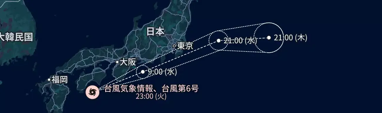
June 2, 2026. As the seasonal rain front stagnates and the signs of early summer begin to drift across the Japanese archipelago, the first major threat of the year approaches. Large and strong Typhoon No. 6 (Asian name: Jangmi) is accelerating northeastward over the sea south of Japan. According to the Japan Meteorological Agency's latest track forecast, the typhoon will come closest to the Kanto region from early morning to just past noon tomorrow, the 3rd, with a high risk of directly hitting the Tokyo metropolitan area during the morning commute and school hours. Already, the Pacific sides of western and eastern Japan are experiencing intermittent heavy rain due to moist air around the typhoon and frontal activity, rapidly increasing the risk of landslides and river flooding in various areas. This article details Typhoon No. 6's current strength and track, the scale of expected damage, comparisons with past typhoons that caused massive damage, and the rapid weather changes after the typhoon passes, from multiple perspectives.
Current Status: Accelerating Towards Kanto While Maintaining Strong Force
As of 18:00 on June 2, 2026, Typhoon No. 6 is over the sea about 40 km south-southeast of Nichinan City, Kagoshima Prefecture, moving northeast at a relatively fast speed of about 40 km/h. The central pressure is 980 hectopascals, with a maximum wind speed near the center of 25 meters per second and a maximum instantaneous wind speed of 35 meters per second.
The biggest concern with this typhoon is that it is approaching Honshu almost without losing strength, influenced by the warm sea surface temperatures of the Kuroshio Current south of Japan. Furthermore, the typhoon is stimulating the seasonal rain front stagnating near Honshu from the south, causing widespread "preceding rainfall" even before the main body of the typhoon approaches. The Japan Meteorological Agency has announced the possibility of "linear precipitation zones" forming over a wide area from southern Kyushu to Tokai and Kanto, urging maximum caution against record-breaking rainfall in short periods.
Peak Hours Hitting the Morning Commute Rush on the 3rd
The time requiring the highest alert, especially in the Kanto region, is from around 6:00 AM to 10:00 AM on Wednesday, June 3, 2026.
According to the track forecast map, the center of the typhoon is expected to pass near the Izu Islands and trace a route extremely close to the coastal areas of Kanto. As a result, wind and rain will intensify in Kanagawa and Chiba prefectures early on the 3rd, and during the commuting hours, a wide area including central Tokyo is expected to see "extremely heavy rain" exceeding 50 mm per hour, and violent winds (maximum instantaneous wind speed of 30-40 meters) that render umbrellas useless.
Impacts on public transportation are inevitable. JR and private railways have announced the possibility of significant delays from the first train, reduced operations when wind speeds reach regulatory limits, or planned suspensions in some cases. Both Haneda and Narita airports are also expected to see a series of cancellations and delays, mainly for flights on the morning of the 3rd, making it essential for travelers to check the latest operation information.
Similarities to 2019
Comparing the strength and track of Typhoon No. 6 with past cases reveals commonalities with two typhoons in 2019 that caused massive damage to the Kanto region.
First, in terms of violent winds, the "Reiwa 1 Boso Peninsula Typhoon (Typhoon No. 15)" comes to mind. At that time, fierce winds blew mainly in Chiba Prefecture, causing large-scale and prolonged power outages due to the collapse of transmission towers. The current No. 6 also has a central pressure and expected wind speeds approaching the level of No. 15, necessitating thorough wind countermeasures in coastal areas.
In terms of rain, similarities with the "Reiwa 1 East Japan Typhoon (Typhoon No. 19)" are pointed out. No. 19 brought record-breaking rain over a wide area not only from the typhoon's main rain clouds but also due to the influence of the front, causing many rivers to flood. The current No. 6 is also strengthening its activity by integrating with the seasonal rain front, requiring caution against the "No. 19 type" damage pattern where heavy rain occurs even in places far from the typhoon's center.
Also, as a June typhoon, it is similar to Typhoon No. 6 in 2002, which also brought flood damage to eastern Japan with unseasonably strong force. A historical lesson is the fact that "just because it's a June typhoon doesn't mean it's weaker than an autumn typhoon."
Serious Blow to Wheat and Fruit Trees in Harvest Season
On the economic front, impacts on the agricultural areas of northern Kanto are particularly concerning. Early June is the wheat harvest season, and lodging (crops falling over) or delays in harvesting due to heavy rain directly lead to a decline in quality. Also, melons in Ibaraki Prefecture and early summer fruits are at risk of losing precious pre-shipment crops due to broken branches from strong winds and damage to greenhouses.
Local governments are urging farmers to take emergency measures such as cleaning drainage channels, reinforcing greenhouses, and inspecting generators for livestock in preparation for power outages.
'Dangerous Extreme Heat' Awaiting After the Typhoon Passes
Attention must also be paid to the weather from Thursday the 4th onwards, after the typhoon has passed.
Because the typhoon brings in extremely warm and moist tropical air, immediately after the typhoon leaves and clear skies spread, a "Foehn phenomenon" may occur on the Pacific side. Particularly in the inland areas of Kanto and Tokai, there is a fear of "extreme heat days" where the maximum temperature reaches 35 degrees, and in some cases, 38 degrees.
When performing clean-up work after the typhoon, the risk of heatstroke becomes extremely high due to high humidity after heavy rain and a rapid rise in temperature. Please be sure to take frequent hydration and breaks, and carry out recovery work after the disaster within a reasonable range.
Preparation Without Fearing a 'False Alarm' to Protect Lives
Typhoon No. 6 could be the first major weather disaster of 2026. Baseless confidence like "It's still June" or "It should be fine with this much" delays judgment and puts lives at risk.
Reconfirm the danger level of your home on the hazard map, and if an evacuation order is issued, promptly perform "vertical evacuation" (moving to a higher floor) or move to a designated evacuation shelter. Clean up items outdoors that can be easily blown away, reinforce window glass, and prepare water and food for several days. These basic preparations are the only way to protect yourself from the worst-case scenario.
If it turns out to be a false alarm, it just means you were "lucky." Assume the worst-case scenario and complete your thorough preparations today.
【Sources】